Search Categories

1

Why We Love It

Reviewers rave about the Garmin InReach Explorer+'s robust build and reliable GPS tracking. The global satellite coverage is a game changer for many users, who appreciate being able to stay connected anywhere in the world. The integrated SOS feature is another highlight, providing peace of mind during outdoor adventures. Users also love the pre-loaded topographic maps, which are detailed and easy to read.

Pros

  • Global satellite coverage
  • Pre-loaded with topographic maps
  • Robust build quality

Cons

  • Subscription required for full features
  • Higher price point

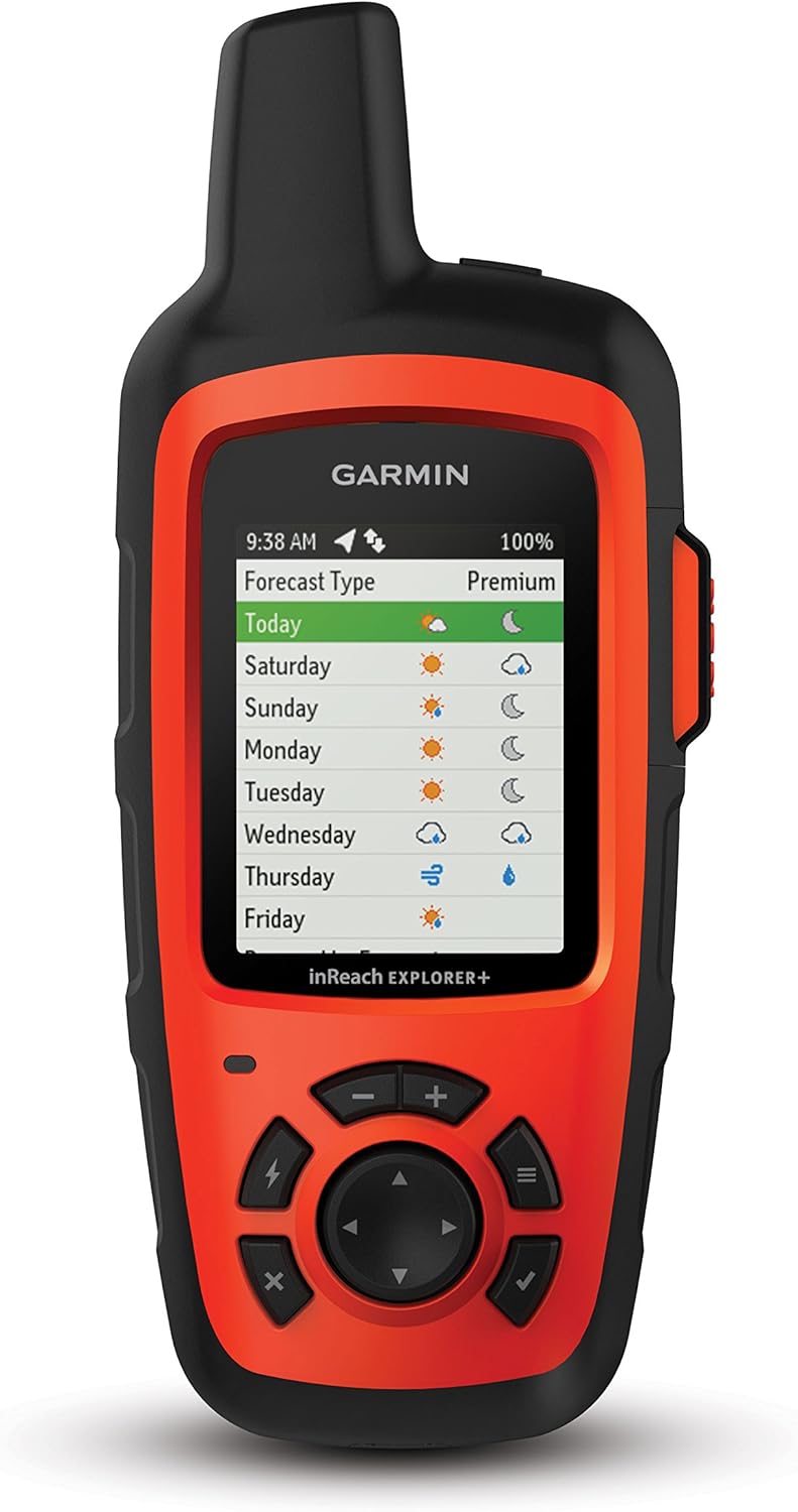
Satellite communicator with Maps and Sensors.

The Garmin InReach Explorer+ is a handheld GPS device with global Iridium satellite coverage. It offers full-fledged GPS navigation, two-way messaging, SOS functions, and weather forecasts. The device is impact-resistant and water-rated to IPX7, ensuring it can withstand harsh outdoor conditions. It features a preloaded DeLorme TOPO maps, built-in digital compass, barometric altimeter, and accelerometer.

2

Why We Love It

Users and reviewers love the Garmin eTrex 10 for its compact size and rugged design, making it perfect for hiking and outdoor adventures. It's also praised for its fast positioning and reliable signal, thanks to its high-sensitivity GPS receiver. Despite its lack of advanced features, many appreciate its simplicity and ease of use, making it perfect for beginners.

Pros

  • Compact and rugged design
  • Fast positioning
  • Reliable signal

Cons

  • Monochrome display
  • Lacks advanced features

Handheld GPS Navigator with worldwide basemap.

The Garmin eTrex 10 Worldwide Handheld GPS Navigator is a great companion for those who love outdoor adventures. It has a preloaded worldwide basemap and supports GPS and GLONASS satellites for improved positioning and typically faster fixes. It features a 2.2-inch monochrome display and a high-sensitivity, WAAS-enabled GPS receiver with HotFix and GLONASS support for fast positioning and a reliable signal.

3

Why We Love It

Users and reviewers love the Garmin Foretrex 401 for its wrist-mounted design, freeing up hands for other tasks. The high-sensitivity receiver is highly praised for providing fast and accurate location tracking. Despite its small display and limited features, many users appreciate its simplicity and functionality, making it a reliable choice for hikers and military personnel alike.

Pros

  • Wrist-mounted
  • High-sensitivity receiver
  • Electronic compass and barometric altimeter

Cons

  • Small display
  • Limited features compared to handheld models

Wrist-mounted hiking GPS with high-sensitivity receiver.

The Garmin Foretrex 401 Waterproof Hiking GPS is a compact, wrist-mounted GPS navigator perfect for outdoor activities that require both hands. It combines a high-sensitivity waterproof GPS receiver, electronic compass and barometric altimeter into a lightweight device. It also features a trip computer, sunrise/sunset times, hunting/fishing information, electronic compass and barometric altimeter. The device keeps track of paths, heart rate and more, making it great for hikers, campers and military personnel.

4

Why We Love It

Reviewers and users appreciate the Garmin inReach Explorer+ for its two-way text messaging feature, allowing them to stay connected even in remote areas. The interactive SOS feature is also highly praised, providing an extra layer of safety during outdoor adventures. Despite its higher price point and the requirement for a subscription service, many users find its features and performance worth the investment.

Pros

  • Two-way text messaging
  • Interactive SOS
  • Preloaded DeLorme topo maps

Cons

  • Subscription service required
  • Higher price point

Handheld Satellite Communicator with Topo Maps and GPS Navigation.

Garmin inReach Explorer+ is more than just a GPS device. It's a rugged, reliable global communication tool, with 100% global Iridium satellite coverage for two-way text messaging. It also offers interactive SOS alerts, GPS navigation, and preloaded DeLorme topo maps; pair with mobile devices using the free Earthmate app for access to downloadable maps, color aerial imagery, and more. It also has a built-in digital compass, barometric altimeter, and accelerometer.

5

Why We Love It

The Garmin Foretrex 401 is praised for its hands-free operation, which users find exceptionally convenient during outdoor activities like hiking, hunting, and fishing. The high-sensitivity GPS receiver is reliable in areas with heavy tree cover or deep canyons, ensuring you always have accurate location data. The dual-position readout is a feature that users appreciate, as it provides flexibility in how they view their location data.

Pros

  • Hands-free operation
  • High-sensitivity GPS receiver
  • Dual-position readout

Cons

  • Small screen
  • No color display

Wrist-mounted GPS navigator with HotFix satellite prediction.

The Garmin Foretrex 401 is a lightweight GPS navigator that straps to your wrist for easy access and hands-free operation. It features a high-sensitivity GPS receiver with HotFix for improved performance and reception in heavy tree cover or deep canyons. The device keeps track of routes, tracks, and waypoints, and has a TracBack feature to navigate back to your starting point. It comes with a dual-position readout so that you can view your current location in multiple formats, including latitude/longitude and military grid reference system (MGRS).

Product Comparison

Compare features across all products in this category

6 Features 7 Products Updated Oct 03, 2025
Product GPS Navigation Display Type Weight Water Resistance Mapping Features Additional Sensors
1 Garmin 010-02064-00 InReach Explorer+
Yes Color 7.5 oz IPX7 Preloaded DeLorme TOPO maps Digital compass, barometric altimeter, accelerometer
1 Garmin GPSMAP 64sx Handheld GPS
Yes Color 8.1 oz IPX7 Preloaded TOPO Active mapping, Birdseye Satellite Imagery None
2 Garmin eTrex 10 Worldwide Handheld GPS Navigator
Yes Monochrome 5.0 oz IPX7 Preloaded worldwide basemap None
3 Garmin eTrex 30x
Yes Color 5.4 oz IPX7 Preloaded TOPO maps 3-axis electronic compass, barometric altimeter
4 Garmin Foretrex 401 Waterproof Hiking GPS
Yes Monochrome 3.5 oz IPX7 None Electronic compass, barometric altimeter
5 Garmin Foretrex 401
Yes Monochrome 3.5 oz IPX7 None High-sensitivity GPS receiver
5 Garmin inReach Explorer+, Handheld Satellite Communicator with Topo Maps and GPS Navigation
Yes Color 7.5 oz IPX7 Preloaded DeLorme topo maps Digital compass, barometric altimeter, accelerometer
1

Garmin 010-02064-00 InReach Explorer+

GPS Navigation
Yes
Display Type
Color
Weight
7.5 oz
Water Resistance
IPX7
Mapping Features
Preloaded DeLorme TOPO maps
Additional Sensors
Digital compass, barometric altimeter, accelerometer
1

Garmin GPSMAP 64sx Handheld GPS

GPS Navigation
Yes
Display Type
Color
Weight
8.1 oz
Water Resistance
IPX7
Mapping Features
Preloaded TOPO Active mapping, Birdseye Satellite Imagery
Additional Sensors
None
2

Garmin eTrex 10 Worldwide Handheld GPS Navigator

GPS Navigation
Yes
Display Type
Monochrome
Weight
5.0 oz
Water Resistance
IPX7
Mapping Features
Preloaded worldwide basemap
Additional Sensors
None
3

Garmin eTrex 30x

GPS Navigation
Yes
Display Type
Color
Weight
5.4 oz
Water Resistance
IPX7
Mapping Features
Preloaded TOPO maps
Additional Sensors
3-axis electronic compass, barometric altimeter
4

Garmin Foretrex 401 Waterproof Hiking GPS

GPS Navigation
Yes
Display Type
Monochrome
Weight
3.5 oz
Water Resistance
IPX7
Mapping Features
None
Additional Sensors
Electronic compass, barometric altimeter
5

Garmin Foretrex 401

GPS Navigation
Yes
Display Type
Monochrome
Weight
3.5 oz
Water Resistance
IPX7
Mapping Features
None
Additional Sensors
High-sensitivity GPS receiver
5

Garmin inReach Explorer+, Handheld Satellite Communicator with Topo Maps and GPS Navigation

GPS Navigation
Yes
Display Type
Color
Weight
7.5 oz
Water Resistance
IPX7
Mapping Features
Preloaded DeLorme topo maps
Additional Sensors
Digital compass, barometric altimeter, accelerometer

Frequently Asked Questions About Hiking GPS Devices

What makes a hiking gps devices the "best"?

We evaluate products based on quality, performance, value for money, user reviews, durability, and ease of use. Our rankings are updated regularly to reflect the latest market offerings and user feedback.

How often do you update your hiking gps devices recommendations?

Our team continuously monitors the market for new products and updates our recommendations quarterly. We also adjust rankings based on user feedback and new testing results.

Do you test all the products you recommend?

Yes, whenever possible, we physically test products in our labs. For products we can't test directly, we rely on verified user reviews, expert opinions, and detailed specifications to make informed recommendations.

What if I'm looking for a specific type of hiking gps devices?

Our top 10 list covers the most popular and highly-rated options. If you have specific requirements, check our detailed product descriptions and pros/cons to find the best match for your needs.